|
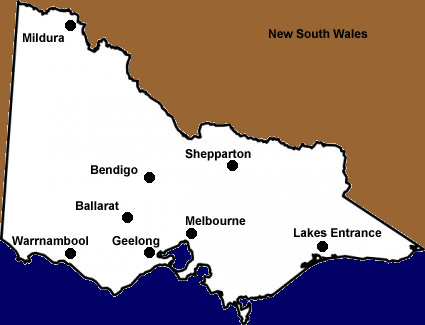
Map
of Victoria

Victoria
is Australia's smallest mainland state in terms of area, but is
the second largest in population.
Situated
in south-eastern Australia, Victoria covers 237,629 sq km.
To
its north, beyond the Murray River is New South Wales, to its west
is South Australia and to the south - across Bass Strait - lies
Tasmania.
The
capital city in Victoria is Melbourne, often winner of the world's
most liveable city title, and home to more than 4 million people.
Melbourne has two thirds of Victoria's population within its metropolitan
area.
Victoria
has a moderate climate and its weather is very changeable. Four
seasons in one day so when out and about you should plan for all
contingencies.
In
the peak of summer the temperatures can hit 45C, while in winter
it can be around 10C - although the wind chill factor coming from
off Antarctica can make it seem much colder.
Being
a compact state it is easy to tour around Victoria.
The
state offers beautiful scenery from the Great Ocean Road from Geelong
to Warrnambool in the south-west, the old goldfields around Ballarat
and Bendigo, the wine country of the Yarra Valley and in the central
and northern areas, snow skiing in the alps and the mighty Murray
River.
Melbourne
is arguably the world's sporting capital and its residents flock
to major sports events. The most popular is Australian Rules Football,
better known as The Footy, and 70 to 80,000 fans attend club matches
at the Melbourne Cricket Ground. In summer the MCG hosts cricket,
Australia's national sport, and of course there is the Australian
Open in tennis at the nearby Melbourne Park complex.
The
city is also famed for its restaurants and you can dine out and
enjoy almost any cuisine or style of cooking from around the world.
Victoria
has a strong political and economic rivalry with its northern neighbour
New South Wales, and a great sorting rivalry with South Australia.
In
the years the Australian capital Canberra was being designed and
built, Melbourne was the acting-capital of the country.
|
